Comparison of atmospheric water vapor data from GNSS and Radiometers
Büsra Korkmaz
As it is known water vapor is one of the most influential greenhouse gas, even it fills only 0-5% of the volume of the atmosphere. The water vapor molecules radiate heat in all directions and some of the heat returns to the Earth’s surface. Thus, water vapor is a second source of warmth, after the Sun. Around 50% of the total atmospheric water vapor is located in the boundary layer, which is about 1.5km above the surface, and less than 5-6% of the water vapor can be found above 5km. There are several ground based methods for detecting the atmospheric water vapor. This work is specialized in the detection with water vapor radiometer and Global Navigation Satellite Systems (GNSS).
With measuring the background microwave radiation, the radiometer is obtaining the amount of atmospheric water vapor. It measures the dual-channel at two frequencies. The first frequency is close to the water vapor line (22.235 GHz) and the other in a window region at higher frequencies (e.g. 31.4 GHz) (Rose et al., 2005). GFZ has two different water vapor radiometers named HATPRO and RADIOMETRICS. They provide vertical profiles of atmospheric temperature & humidity, the integrated water vapor and liquid water.
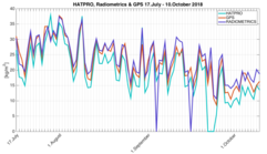
To determine the atmospheric water vapor from GNSS measurements, the Zenith Total Delay, including Zenith Wet & Zenith Hydrostatic Delay, has to be obtained from the Atmospheric delay using different mapping models. After getting the Zenith Total Delay, the Zenith Hydrostatic Delay can be computed with the usage of Saastamonien (1972) model. Subtracting the Zenith Hydrostatic Delay from the Zenith Total Delay gives the Zenith Wet Delay. With use of the conversion parameter, which is a function of the weighted mean temperature, the Integrated Water vapor can be obtained. An analysis of the water vapor measurements of two different water vapor radiometers and the GPS station, located at GFZ, was done. During the analysis GPS was set as a reference, because of its high accuracy (3mm). The difference of the water vapor measurements between the two different radiometers were analyzed with respect to the GPS measurements.
The differences in the measurements of the two radiometers HATPRO and RADIOMETRICS to the reference GPS measurements were higher than expected. Also it came out that the rain sensitivity changes with each Instrument, which strongly affects the measurements. Especially the RADIOMETRICS water vapor radiometer has big problems with the data availability. A big motivation for future work is the improvement of the radiometers to get better results with respect to the GNSS measurements.
References
Rose, T., Crewell, S., Löhnert, U., and Simmer, C.: A network suitable microwave radiometer for operational monitoring of the cloudy atmosphere, Atmos. Res., 75, 3, 183–200, doi:10.1016/j.atmosres.2004.12.005, 2005.
Saastamonien, J., Atmospheric correction for the troposphere and stratosphere in radio ranging of satellites, in The Use of Artificial Satellites for Geodesy, Geophys. Monogr. Ser., vol. 15, edited by S. W. Henriksen et al., pp. 247-251, AGU, Washington, D.C., 1972